I didn't know this before but Brittany is recognized as one of 6 Celtic nations in the world. The others are Ireland, Wales, Cornwall, Isle of Man, and Scotland. The Bretons in Brittany arrived from Great Britain in the 5th century, escaping the invasion of the Anglo-Saxons who were conquering Great Britain. (Could that be one reason so many Brits vacation in Brittany? Of course, proximity, sunshine and beaches may also have something to do with their summer migration.)
I also didn't realize that Bretons are not Gauls even though both Gauls and Bretons are Celts. So confusing. I always envisioned Asterix and Obelix, both Gauls, living somewhere in Brittany. Turns out they lived farther north.
 |
| Obelix - menhir - Asterix |
But today, we're looking at evidence of civilizations even older than Asterix and Obelix. Between 4500 BC and 2000 BC, the inhabitants of Brittany created what we call megaliths: dolmens, cairns, tumuli, and menhirs. Basically, these are giant sized rocks used alone or together to create some sort of monument.
A menhir is a rock stood vertically in the ground. There can be only one or many.
 |
| line of menhirs at Er Lannic not far from us |
A dolmen (from the Breton word meaning stone table) is a large flat rock supported by vertical rocks. These were used as burial chambers.
 |
| Clark pushing the stone into place at the Dolmen de Kerlud. How did they get it to lie on top of the vertical stones? |
 |
| Janis trying not to bump her head on the way out of the Dolmen de Kerlud. But how did they move it miles to get here? And why here? Mysteries never to be answered, I think. |
The definitions of tumuli and cairns seem confusing to me. They are both chambers covered in stone and earth. A tumulus is always a burial chamber but a cairn can have several chambers not necessarily for burial. So I'm not going to try to differentiate them. Maybe you can figure out how they're different
 |
| The Tumulus of Er-Grah at Locmariaquer is one of the largest in the world |
Who built them or what significance they had is unknown, but hypotheses surrounding funereal rites seem to hold water. The people who built these monuments had some sort of efficient process that required enormous cooperation among many people to first dig the stone out of the dirt or free it from surrounding rock and then move it several miles before lifting it somehow to put it in place. The average weight of stones is around 50 tons, while the great menhir at Locmariaquer weighs 280 tons. Whatever neolithic people built these monuments, their history is a mystery.
So we're off this morning to Locmariaquer to see some of these megaliths up close and personal. This town is on the other side of the Auray River ria (a long, narrow inlet formed by a partially submerged river). We have to drive as far as Auray to cross the river and then head south.
The megaliths of Locmariaquer are part of a national historic site (number 1 on the map below) which has a visitor center and an entrance fee. Well worth the money. We started with an introductory video that we listened to in English through a headset before exiting the building to see three important megaliths.
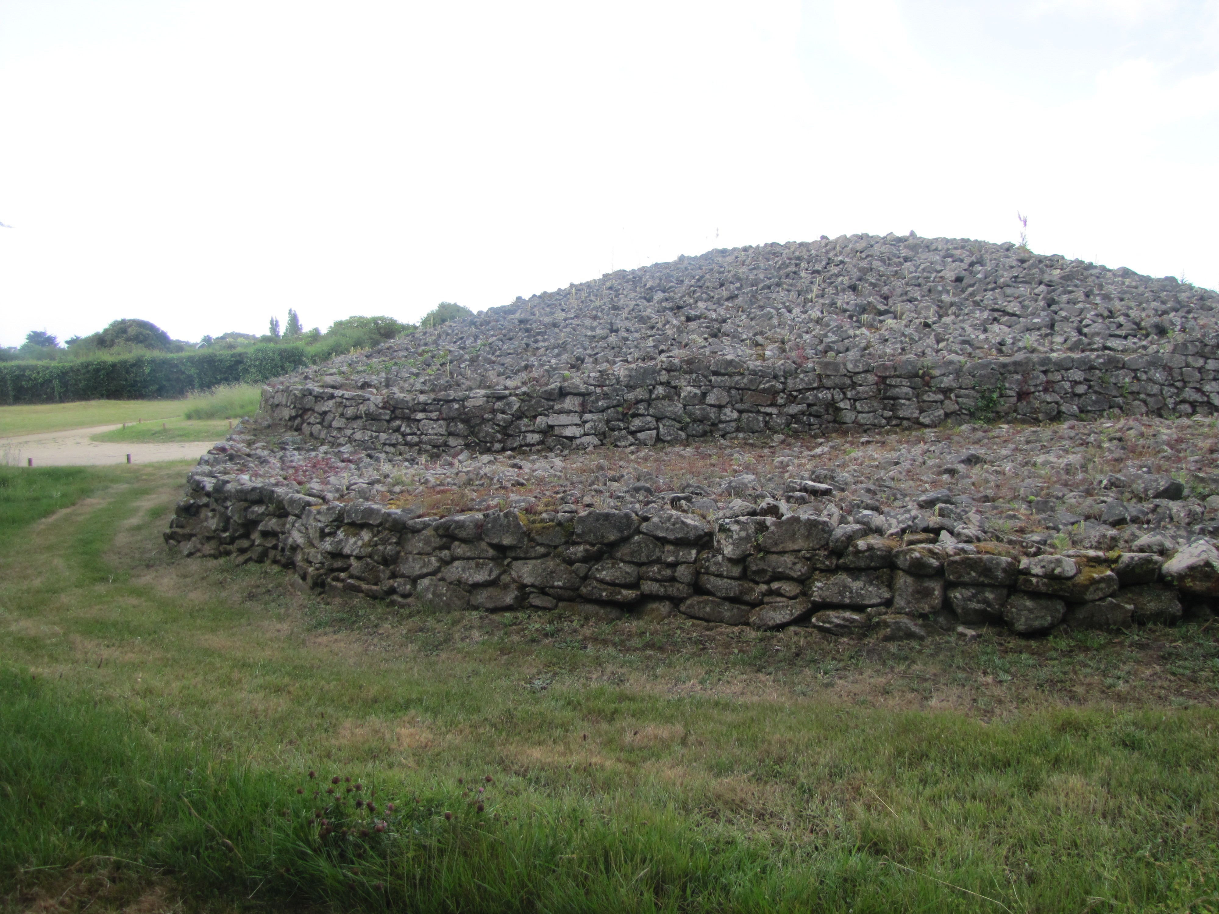
The 140 meter Er-Grah tumulus is the first megalith you see after leaving the building.
Built in phases from 4500 BC to 4000 BC, this tumulus covers several burial chambers. The path walks you around the entire length of this chamber which has no visible entrance. It has been excavated, studied, and restored to its original condition.
The Table des Marchands is a dolmen built in 3900 BC. (How do they know that?) It is also a cairn because it is covered in stacked stones.
 |
| Dave standing outside the entrance to La Table des Marchands |
 |
| Lynn standing at the end of the entry passage. Behind, the burial chamber opens into a room. |
 |
| Carving on the ceiling stone of La Table des Marchands |
Archeological excavations have revealed some interesting features of this dolmen. The stone at the back of the dolmen is older than the dolmen itself and it has carving on both sides.
 |
the back wall of the Table des Marchands is covered in carving. Notice the stones stacked in the corners of the vertical stone.
|
This stone was once part of a row of great menhirs (which was destroyed at the time of building this dolmen), left in place and reused to build this dolmen. The top of this huge menhir was broken into 2 pieces which have been reused. The top 5 meters was used to cover the Er-Grah tumulus. The middle 4 meter piece was used in the dolmen at Gravinis (4 km away from this site).
The 3rd megalith at this site is the broken Great Menhir.
 |
| the broken Great Menhir |
This stone was part of a row of 18 menhirs. It was cut from a type of granite not found in this area and moved several kilometers by neolithic men who smoothed its surface using stone Erected in 4500 BC, this 20 meter, 280 ton megalith fell after 2 or 3 centuries. Perhaps an earthquake? Perhaps destroyed intentionally? It now lies in 4 enormous pieces on the ground. The stone had been smoothed using quartz hammers. (How does that work?)
 |
| the broken Great Menhir |
My impressions after seeing these amazing megaliths:
- Clearly neolithic communities were large enough to provide the manpower needed for such enormous tasks.
- Clearly, they used technologies for cutting, moving, and erecting these stones.
- And clearly, these monuments had spiritual meaning to the communities that built them.
- Neolithic society was both complex and intelligent.
- I feel humbled in meeting the work of these people.
- I wish we could know more about who these people were.
There are other dolmens near here, but not in the museum area. We need to take the car to find them. Dave has mapped out a route for the afternoon.
 |
| our itinerary for dolmen hunting |
The Tumulus du Mané-Lud, located just outside Locmariaquer (number 2 on the map) isn't much to look at from the outside but it's the same claustrophobic design on the inside.
 |
| Clark making his way out the passageway. |
 |
| the tumulus of Mané-Lud |
We need a lunch break. The port at Locmariaquer is a perfect spot - scenic, stones to sit on, and lots of sun.
 |
| finding a good seat |
 |
| panorama of our view |
 |
| Clark and Janis are ready for lunch |
 |
| the port in front of us |
The Dolmen der Kerlud (number 4 on the map) is the next stop, just one kilometer outside of Locmariaquer. It has an impressive stone covering its vertical stones. It is right next to a farm house.
 |
| Dolmen de Kerlud |
 |
| entrance to Dolmen of Kerlud |
We next headed to the beach to find the Dolmen des Pierres Plates (flat stones) (number 5 on the map). This dolmen is fenced off, so you can't enter it, but it has a beautiful location on the beach.
 |
| map showing the size and layout of the Pierre Plates Dolmen |
The last stop of the day (number 6), the Point de Kerpenhir, is also along the beach where the point of land separates the Gulf of Morbihan from the Atlantic Ocean. The granite statue of Our Lady of Kerdro stands on this point of land to protect sailors.
 |
| Our Lady of Kerdro |
 |
| Point de Kerpenhir |
 |
| Point de Kerpenhir |
Are you tired yet of dolmens? We are. Time to go home for apéros.


No comments:
Post a Comment